Curaçao Wind Speed Maps
Work with your preferred spatial analysis platform to conduct in-depth analysis and create wind maps. Access comprehensive wind data provided in standard GIS-compatible formats for Curaçao.

Dataset Information
Land Area
437 km²
Hub Heights Available
10m - 140m
Resolution
200m
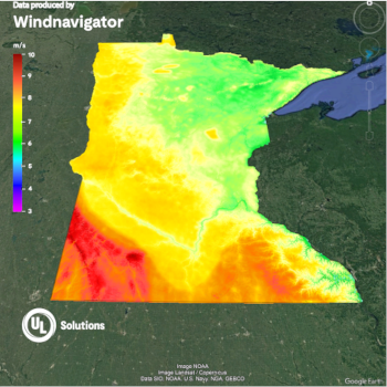
Explore this data online: Navigate wind patterns, elevation, and surface roughness across Curaçao using our Windnavigator Platform.
Register your free account
Additional data products: The Windnavigator platform also enables you to generate
historical time series and virtual met mast data
for Curaçao, as well as order high-resolution
wind resource grids (WRG)
to support detailed micrositing, energy assessments, and seamless integration with wind farm design tools like Windographer and Openwind.
What is included
Raster Data
- Format: GeoTIFF
- Resolution: 200m
- Annual Average Wind Speed at user-defined hub heights
- Digital Elevation Model (DEM)
- Roughness
Vector Data
- Format: Geopackage or ESRI Point Shapefiles
- Resolution: 2km
- Wind Distribution Data (wind speed, power, Weibull A and k, and frequency percentages in 1 m/s bins)
- Annual Average Wind Speed at four user-defined hub heights
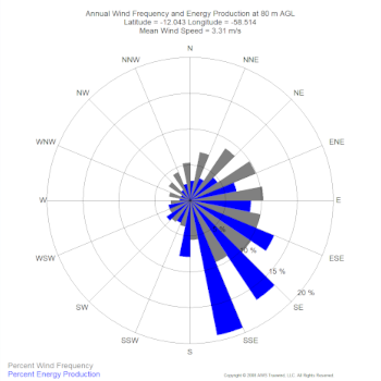
- Wind Rose - frequency and speed in 16 direction sectors
- Roughness
- Monthly Data - average annual wind speeds by month
- Diurnal Data - average annual wind speeds by hour
- Air density, Power density & Weibull parameters new
KML Files
- Format: .KMZ
- Resolution: 200m
- View and modify map in Google Earth
- Annual Average Wind Speed at user-defined hub heights
Download the Curaçao wind map (PDF)
Enter your details and we'll email you a download link for the Curaçao wind speed map.
Tip
Integrate this data with OpenWind to determine your offsets and developable areas for comprehensive wind farm planning. Learn more about OpenWind.