UL Solutions releases the new Windnavigator
Jun 17, 2024
The platform provides a revamped user interface, smart data access, and a streamlined user experience. Windnavigator is a convenient online platform that provides reliable, high-quality wind resource data for prospecting and development. The new Windnavigator will enhance the current platform by providing a revamped user interface, smart data access, and a streamlined user experience.

Highlights of the new Windnavigator platform include:
- Graphic access to previous products: Enjoy a modern dashboard that allows you to locate all your previous WRGs and WRF time series directly on the map.
- Smart search for available products: The new platform lists all the products available for the site of search, including maps in GIS format, WRGs, time series or other available documents such as model validations.
- RRAP included with your subscription: Windnavigator users can now use the same credentials to access the Renewables Resource Assessment Platform.
- Purchase based on credit system: Products can now be acquired based on a simplified credits model, which provides flexibility and adaptability to real consumption.
- ULTRUSTM integration: Starting June 25th, Windnavigator will join the ULTRUSTM platform, which brings together UL Solutions’ flagship software offerings.
Products you can obtain from the platform include:
- WRG200: pre-adjusted high-resolution grids for prospective prospecting when measurements aren’t yet available
- WRG50: ultra high-resolution grids for horizontal extrapolation in last phases of project development
- WRF Time Series: to understand seasonality and conduct measure-correlate-predict (MCP) analyses
- Maps: in GeoTIFF format with 200m resolution covering large areas / countries
- Reanalysis: unlimited access to automated Reanalysis downloads for your site
What’s new in Windnavigator?
Revamped user interface
Totally redesigned system to provide improved functionality and scalability for the future.


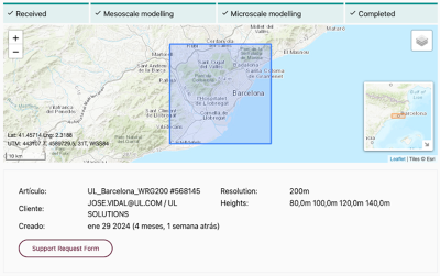
Access to previous orders through the map
The user can now review the exact location of previous orders and avoid duplication of work.
View details of your orders
Relevant details such as who placed the order, when the order was placed or the heights requested are now easily available.


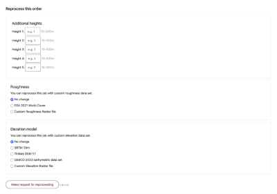
Reprocess WRGs
If you need to process more heights or run the model again using a different elevation or roughness database, you can now do it directly from the platform and receive the results immediately.
Smart search of available products
Clicking on a point in the map, the system tells you which data products are available for the site.

Should you have any inquiries, proposals, or simply an interest in exploring our digital solutions, we warmly invite you to reach out to us.