New Brazil Wind Atlas in Windnavigator Software
Mar 20, 2026
The new Brazil wind map released on UL Solutions' Windnavigator Resource Data and Maps software1 is a major update to the prior map that was released in 2024. The 200-m resolution mean wind speed maps are created with UL Solutions' proprietary wind flow modeling system consisting of a coupled mesoscale and microscale model. The model outputs are subsequently fine-tuned with wind measurements from UL Solutions' large database of met stations. The new wind speed map was validated against 216 met stations in Brazil, the same met stations used in the prior Brazil map of 2024. The latest Brazil wind map (2026) was compared to the prior Brazil map (2024) as well as the Global Wind Atlas (Davis et al. 20232). The 2026 wind atlas of Brazil not only provides more accurate data and at higher heights (up to 300 m) but also leverages the latest advancements in wind modeling technology, especially regarding the mesoscale numerical weather prediction modeling. It offers enhanced insights when analyzing and prospecting greenfield sites and assessing competing projects. These enhancements are designed to help wind developers make more informed decisions.
Table 1: Comparison of 2026 Brazil wind map against UL Solutions' 2024 version and the Global Wind Atlas
| Map | MBE (m/s) | STDEV (m/s) | RMSE (m/s) | R2 | Sample size |
|---|---|---|---|---|---|
| Global Wind Atlas | 0.02 | 1.02 | 1.01 | 0.36 | 216 |
| UL Solutions 2024 map | -0.01 | 0.60 | 0.60 | 0.55 | |
| UL Solutions 2026 map | -0.05 | 0.46 | 0.46 | 0.68 |
Enhanced Wind Map Heights
The new Brazil wind atlas is available at several heights ranging from 10 m to 300 m above ground level. This is a welcome improvement to our original maps which were limited to 140 m height. Given the additional heights, the new maps are especially useful for projects involving taller wind turbines, which are becoming the norm for modern wind farms.Improved Wind Modeling and Accuracy
The coupled mesoscale-microscale modeling system was upgraded to take advantage of new developments in mesoscale modeling and reanalysis datasets. UL's wind modeling system relies on the Weather Research and Forecasting (WRF) mesoscale model and the fifth generation ERA5 reanalysis dataset. The 2026 Brazil reflect a notable improvement in wind speeds due to the upgraded modeling system based on the WRF mesoscale model and the ERA5 reanalysis. These refinements provide a better representation of wind patterns and reduce the margin of error in wind speed estimations.Critical Tool for Greenfield Prospecting
One of the primary use cases of Windnavigator's new Brazil American map is greenfield prospecting. For developers looking to identify the best locations for future wind projects where measurement data may not yet be available, these maps should serve as a trusted and practical wind prospecting tool. The 2026 update reduces the uncertainty with early-stage project development, helping developers lower overall project costs by providing more accurate wind speed predictions and site conditions.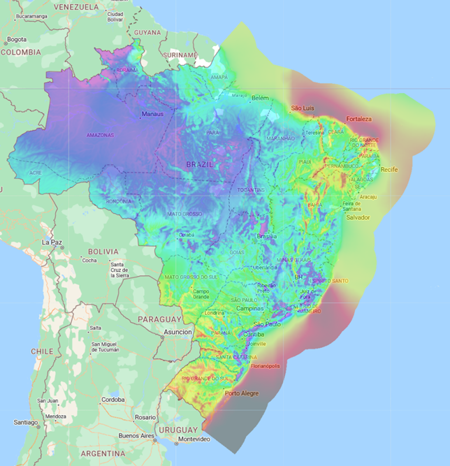
Figure 1.1: Brazil mean wind speed map at 160 m a.g.l.
1 https://wn.ul-renewables.com/dashboard
2 Davis, N.N., et al. (2023) "The Global Wind Atlas: A high-resolution dataset of climatologies and associated web-based application". Bull. Atmos. Met. Soc., vol. 104, pp. E1507-E1525, DOI: https://journals.ametsoc.org/view/journals/bams/104/8/BAMS-D-21-0075.1.xml
Should you have any inquiries, proposals, or simply an interest in exploring our digital solutions, we warmly invite you to reach out to us.